Archive for the ‘Top story of the day’ Category

Lewis County flood risk over, for now except for some pasture lands

Monday, December 13th, 2010

By Sharyn  L. Decker
Lewis County Sirens news reporter

CHEHALIS – Emergency responders from Randle to Rochester are ramping down from a weekend on high alert for possible floods.

“Right now I’m moving the fire trucks from Adna school back down to the station, ’cause I’m thinking it’s done and over with,” Chief Bud Goodwillie of the rural Chehalis fire department said this morning.

It’s been nice and quiet, Goodwillie said.

Forecasters issued flood watches on Friday morning for much of Western Washington expecting a tremendous amount of rain, combined with high snow levels.

“The heavy rain did start in the southern parts but it moved to the northern parts,” National Weather Service meteorologist Johnny Burg said this morning.

Heavy rains of two to five inches fell over the lowlands and up to 10 inches came down in the mountains, according to the National Weather Service.

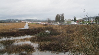
A flood warning remains in effect for the Chehalis River at Centralia through tomorrow morning but firefighters there and in Chehalis are relaxing a little, not having seen yet any effects of the rising waters. The weather service predicts the river will crest late there this afternoon near flood stage and could spill onto nearby pasture lands.

In the Boistfort Valley, the river levels are coming down, according to Fire Chief Gregg Peterson.

“All I heard from my people last night, it was not over any roads but was certainly getting in the fields,” Peterson said.

Pe Ell area Fire Chief Mike Krafczyk this morning said it didn’t cause any problems in the far west end of the county.

“I was monitoring all weekend and the ditches are holding,” Krafczyk said. “Stowe Creek was a good six to eight feet below its banks.”

The creek is known to spill over and run down Main Street when waterways get too high, he said.

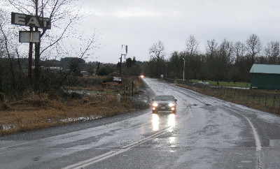
Outside Randle, water did run over Peters Road,  and also state Route 131 which turns into Forest Service Road 25. The latter road was closed this morning about a mile south of town, according to Lewis County Fire District 14 Chief Jeff Jaques.

Rochester-area Fire Chief Robert Scott reported a similarly uneventful weekend and returned to work as usual after the hearing latest weather reports.

“We were ready to ramp up Sunday morning, then we downsized,” Scott said.

The storm system that came through is what’s known a as Pineapple express, nicknamed that way because it brings lots and lots of moisture with connections to the tropics, like Hawaii, meteorologist Burg said.

“Very wet and very warm,” he said. “When we get those, not only do we get lots of rain, but the snow level is high and the mountains squeeze out water.”

They tend to occur here every couple of years, with the last most memorable one in December of 2007, he said.

Burg said weather watchers were looking at the system for about a week in advance, but what they couldn’t pin down was when and where the heavy rain would occur.

The troubling weather system is now well southeast of the state, the weather service reports.

However, there remains a continued risk of landslides in Western Washington, the National Weather Service cautioned this morning. Cumulative rains over the past three weeks have soaked the ground, contributing to soil instability.

“Several landslides have already been reported around Western Washington, and additional landslides are possible,” the weather statement reads. “A gradually diminishing risk of landslides will continue for several days.”

•••

This news story has been updated to reflect the correct name of Stowe Creek.
Update: Newaukum River now expected to crest about 10 p.m. tonight

Sunday, December 12th, 2010
2010.1212.rice.road.lowspot_2

Rice Road in front of Stan Hedwall Park in Chehalis is usually among the earliest places to become inundated when the Newaukum River gets high, and it was passable at 4 o'clock this afternoon.

By Sharyn  L. Decker
Lewis County Sirens news reporter

This news story was updated at 6:12 p.m.

CHEHALIS – While the weather service’s mid-day bulletin says heavy rain has returned to the southern tier river basins as a front moves southeast, still only minor flooding is forecast on the Newaukm River near Chehalis.

The National Weather Service now predicts the river will rise above flood stage around 9 p.m. tonight and crest at 10.7 feet about an hour later. Flood stage is 10.5 feet.

At 4 p.m. today, the chief for Lewis County Fire District 6 was driving around the district and said he hadn’t seen water over any roadways. The district stretches from Adna to North Fork Road and includes both the Newaukum and Chehalis rivers.

Chief Bud Goodwillie said he had just come from one Newaukum low spot, Hamilton at Labree Road and it was fine.

Chehalis police Sgt. Gary Wilson said late this afternoon he checked two normally early trouble places – Shorey Road southwest of the Interstate 5 and Main Street interchange as well as Florida Avenue – and found water was high but not on the roadways.

The weather service lists numerous roads and areas around the Newaukum River that would be affected if the water rises to predicted levels such as Jackson Highway and roads such as Rush, Sommerville, Griel, Hamilton, Tune, Tauscher, Guerrier, Kirkland, Macomber, Rice, Senn, Lucas Creek, Middle Fork and North Fork.

The flood warning continues for the Newaukum River around Chehalis until Monday morning.

In the southwest region, a flood warning continues also on the Chehalis River near Grand Mound and Porter.

The weather service notes advisories are in place about small stream and urban flooding across the forecast area. Flood watches are in effect  through tomorrow afternoon.

•••

Note: At 5:32 p.m., the weather service reinstated a flood warning at Doty for the Chehalis River. It’s only for minor flooding, but obviously  the forecast changes more quickly than I can keep up, and what happens out west affects what happens along the Chehalis River in Chehalis and Centralia. Readers can easily monitor the river levels with the links below.
•••

Read the latest warnings, watches and special weather statements here

Check the river level forecast for your area here

Check the weather forecast or your area here

KOMOnews.com is reporting on water-related events around Western Washington.

Note: Readers can always access the above forecasts from the right hand sidebar on Lewis County Sirens, under “Other useful web links.”

2010.1212.13th.lookingnorth_2

It was not even 4 p.m. today and it was getting dark. Interstate 5 to the north of the 13th Street and Rice Road interchange has a low spot that Dillenbaugh Creek, and subsequently the Newaukum River, have flooded in the past.

Update: Overnight rain moved north, but authorities say watch for changes

Sunday, December 12th, 2010

By Sharyn  L. Decker
Lewis County Sirens news reporter

CHEHALIS – Heavy rains shifted north overnight prompting cancelations of flood warnings on the Chehalis, Skookumchuck and Cowlitz rivers.

A flood warning continues for the Newaukum River around Chehalis until Monday afternoon, however only minor flooding is forecast now.

The city of Centralia was set to open its emergency operations center at 6 a.m. today, however, by 7 a.m. it was closed because of the most recent forecast from the National Weather Service.

The sandbag station on the 100 block of West Street will remain open but won’t be staffed, according to a news release.

Police Chief Bob Berg advises the public to continue to stay informed about any changes in the weather by listening to local radio stations.

Just before 4:30 a.m. today, the weather service said the rain shifted into Central and Northwest Washington but the front is forecast to move back to the south later today with increasing rain expected this morning and into the afternoon.

In the southwest region, flood warnings continue also on the Chehalis River near Grand Mound and Porter.

At the same time this morning, the weather service noted advisories about small stream and urban flooding across the forecast area. Flood watches are in effect.

Overnight, forecasters warned of an increase risk of landslides in Western Washington. Cumulative rains over the past three weeks have soaked the ground. Under those conditions, landslides are possible during intense rainfall, or when the amount exceeds two inches in 24 hours, the weather service cautions.

Two landslides have already been reported, one near Vancouver and one near Chuckanut Drive, the weather service reported about 1:30 a.m. today.

Boistfort area Fire Chief Gregg Peterson reported the fire department has been monitoring the river levels during the dark hours and area residents may see fire vehicles with green rotating lights patrolling the district.

“Nothing flood-wise happened out here,” Peterson reported just after 7 o’clock this morning.

The flood watch in portions of Western Washington remains in effect through Monday afternoon, including in Mason, Thurston, Lewis and Grays Harbor counties.

•••

Read the overnight warnings, watches and special weather statements here

Check the river level forecast for your area here

Check the weather forecast or your area here

Note: Readers can always access the above forecasts from the right hand sidebar on Lewis County Sirens, under “Other useful web links.”

Update: Chehalis River forecast to cause moderate floods at Centralia beginning tomorrow evening

Saturday, December 11th, 2010

By Sharyn  L. Decker
Lewis County Sirens news reporter

CHEHALIS – Rain associated with a strong warm front spread out over Southwest Washington this afternoon and is expected to continue tonight and tomorrow, with flood warnings in effect on several area rivers including the Chehalis River.

Tonight’s flood statement from the National Weather Service said minor flooding is expected from the Chehalis River at Doty, beginning about 1 o’clock tomorrow morning and cresting there by 4 a.m.

As the river moves through Chehalis and into Centralia, it will cause moderate flooding, according to the Weather Service.

Near Mellen Street in Centralia, it should spill over it banks about 6 o’clock tomorrow night and then crest about 10 a.m. on Monday, according to the flood statement issued tonight.

Forecasters expect major flooding as it reaches Grand Mound.

Authorities are urging the public to listen to local radio for updates, and to make sure to be adequately prepared beforehand.

Lewis County Sheriff Steve Mansfield reminds folks they can monitor emergency alert systems such as a NOAA Weather Radio and use the county’s “code red” system.”

Mansfield warns citizens sandbags won’t likely save their homes if a person doesn’t have a large enough inventory as well as a prepared response for how to use them. The sheriff indicated the county doesn’t have enough to handle all the private sandbag requests they get during an event.

The city of Centralia will be offering sand bags and sand for its residents beginning at 7 a.m. tomorrow at three locations: the 100 block of West Center Street, Summa Street on the east side of the mainline railroad tracks and the northeast corner of Reynolds Avenue and Pearl Street.

Police officers will be there confirming addresses since only city residents are eligible, according Police Chief Bob Berg.

Flood stage on the Chehalis River in Centralia is 65 feet. It’s forecast to reach 70.6 feet Monday morning and won’t return to below flood stage until Tuesday morning, according to the Weather Service.

At 68.5 feet, the river will flood some residential and commercial areas with water encroaching on the first floors of some buildings.

Swift water will cover some roads, leading to the reminder that most flood-related deaths in the state come from cars, vans and trucks driving through flooded areas.

Forecasters also say minor flooding from the Skookumchuck River at Centralia will begin around 12 a.m. Monday. The river will crest there about 4 a.m. It will affect farmlands and also some roads.

The Skookumchuck is expected to cause moderate flooding at Bucoda before that. The Weather Service reports it will crest a little more than two feet above flood stage around 4 a.m. Monday.

Out west, in the areas around Doty, forecasters say residents should expect water from the Upper Chehalis River and the South Fork Chehalis River to inundate many roads and some residential and commercial areas.

Flood stage for the Chehalis River is 13 feet at Doty and the river will reach 13.1 feet, according to tonight’s forecast.

Impacted roadways and surrounding areas out there include Moon Hill, Wildwood, Lake creek, Curtis Hill, L Abri and Front Street, according to the weather service.

The expected levels of the Chehalis River correspond to a phase two flood under the Lewis County flood system.

The Newaukum River is also expected to cause moderate flooding, and the latest statement from the weather service suggests its beginning later than previously expected.

Forecasters now suggest it will overflow beginning about 10 p.m. tonight but still crest at Chehalis at about 13 feet around 4 p.m. tomorrow afternoon.

The statement issued just before 8:30 p.m. tonight calls the Newaukum’s expected levels a phase three flood under the Lewis County flood system. Several more roads were added which could be impacted, including Bishop, Shorey, Labree, Gish and Yates.

The Newaukum is expected to fall below flood stage Monday afternoon.

The warnings are accompanied by others issued today of moderate flooding from the Cowlitz River near Randle and minor flooding on the Nisqually River near National affecting Lewis and Pierce counties

•••

Read the latest flood warnings, watches and weather statements here

Check the river level forecast for your area here

Check the weather forecast or your area here

Update: Newaukum River to spill over banks tonight

Saturday, December 11th, 2010
2010.1211.weathermap.sat.even

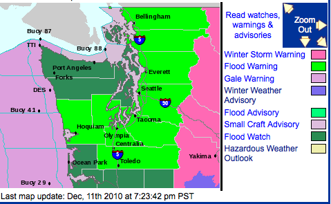
The lime green areas are counties where flood warnings have been issued, most of them today. Courtesy picture / National Weather Service

By Sharyn  L. Decker
Lewis County Sirens news reporter

CHEHALIS – Moderate flooding is forecast on the Newaukum River at Chehalis beginning about 8 o’clock tonight, according to the National Weather Service.

Heavy rain has begun to develop over far southern Washington, the weather service reported at mid-day today. It’s expected to continue tonight and tomorrow driving streams in the Chehalis drainage to flood stage.

The Newaukum River is expected to crest about 4 p.m. tomorrow near 13 feet. Flood stage is 10.5 feet.

At that level, flood waters will inundate many roads residential areas and commercial areas along the river and its forks, according to the Weather Service.

The Weather Service cautions flooding in some areas may be deep and hazardous, especially near rivers.

The expected levels correspond to a phase two flood under the Lewis County flood system.

Impacted roadways and surrounding areas include Jackson Highway and roads such as Rush, Sommerville, Griel, Hamilton, Tune, Tauscher, Guerrier, Kirkland, Macomber, Rice, Senn, Lucas Creek, Middle Fork and North Fork.

The Newaukum River is expected to fall below flood stage Monday afternoon.

The warning is accompanied by other flood warnings issued today on the Cowlitz River near Randle; the Skookumchuck at Centralia and Bucoda; and the Chehalis River at Doty, Centralia and Ground Mound.

Higher elevations in the Willapa Hills and Central Cascades are likely to receive 3 inches to 7 inches of rain during the period, according to the forecasters.

Most flooding will be moderate, except the Chehalis River near Grand Mound is expected to produce major flooding, the warning notes.

Minor flooding is expected on the Nisqually River near National affecting Lewis and Pierce counties.

More coming

•••

Read the latest flood warnings, watches and weather statements here

Check the river level forecast for your area here

Check the weather forecast or your area here

Update: Cowlitz at Randle added to rivers with flood warning

Saturday, December 11th, 2010

By Sharyn  L. Decker
Lewis County Sirens news reporter

Moderate flooding is expected on the Cowlitz River at Randle, which will rise above flood stage about 10 a.m. tomorrow, according to a flood warning issued this afternoon.

The National Weather Service forecasts the river will crest around about 10 p.m. tomorrow night at 20.5 feet.

Flood stage there is 18 feet.

At 20 feet, the river will cause flooding around Randle and downstream through Riffe Lake, inundating many roads including U.S. Highway 12 as well as much of the farmlands, according to National Weather Service.

The river should fall back below flood stage Monday evening, according to the weather service.

A winter weather advisory is also in place for the Randle area.

The warning on the Cowlitz is accompanied by a warning of minor flood on the Nisqually River near National affecting Lewis and Pierce counties.

At mid-day, flood watches were upgraded to flood warnings on several Southwest Washington rivers including the Chehalis, Newaukum and Skookumchuck rivers.

More coming

•••

Read the latest flood warnings, watches and weather statements here
Check the river level forecast for your area here
Check the weather forecast the Randle area here

Narcotics overdoses in Centralia

Friday, December 10th, 2010

By Sharyn  L. Decker
Lewis County Sirens news reporter

Local firefighters and paramedics have been talking among themselves, wondering what’s up with drug overdoses.

In Centralia, Assistant Fire Chief Mike Kytta said responders have dealt with emergencies recently, including a pair of individuals at the same residence.

“Within the last week, we’ve answered three EMS calls for patients that may or may not have been attributed to heroin overdoses,” Kytta said on Wednesday. “We can’t say in the field for sure, the hospital will do that.”

None of them were reported to have subsequently died.

Paramedics can and do use a drug called Narcan that quickly counteracts the effects of depressants, according to Kytta.

“Within a matter of literally minutes, you’ll see an unconscious, unresponsive person start to awaken and their respiration will increase; they’ll appear relatively normal,” Kytta said.

The three cases Kytta spoke of all occurred last Friday and Saturday, and if indeed they were all related to heroin, that would be a high occurrence rate in a short period of time, he said.

Kytta, the assistant chief for Riverside Fire Authority which covers the greater Centralia area, said he wasn’t able to talk in much more detail about their medical calls.

A Centralia Police Department spokesperson said this week he was aware of one recent case where the fire department was called to what might have been a drug overdose. Officer John Panco said police wouldn’t necessarily be able to say if there was more than the usual number of incidents, as the fire department handles them.

Centralia police Sgt. Jim Shannon, who supervises the department’s drug enforcement team, said heroin use in the area is definitely on the rise.

“Methadone is big as well,” Shannon said.

Shannon said Oxycontin was very popular for a long time and a lot of young people got hooked.

All three drugs are central nervous system depressants and users may prefer one, but might choose another depending on availability, according to Shannon. Oxycontin has become harder to come by, he said.

What he and his officers find in Centralia is black tar heroin, he said.

“It’s readily available, it cheaper, it’s easier to get,” Shannon said.