Updated at 1:40 p.m.
By Sharyn L. Decker
Lewis County Sirens news reporter
CHEHALIS – Remember early January in 2009, when the water from flooded swamplands next to Interstate 5 near 13th Street in Chehalis spilled onto the freeway, shutting down the normally busy north-south corridor?
Anyone in the Newaukum River Valley remember the winter before, the morning of Dec. 3, 2007?
How about February 8, 1996?
Weather forecasters say snow, changing to rain late tonight in the mountains, means flooding is possible tomorrow, for some of Western Washington.
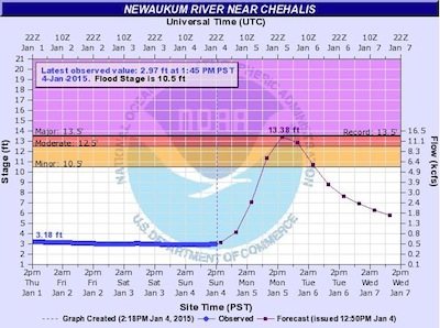
While the flood watch notes the upper Cowlitz River in Lewis County is among those at greatest risk, the prediction service’s current graph shows flooding of the Newaukum River could surpass each of those three events, by an inch or two.
The National Weather Service urges the public to stay tuned to its website for further updates.
The heavy rainfall would also lead to a moderate risk of landslides, according to the weather service.
In January 2009, the combination of water on Interstate 5 and mudslides on U.S. Highway 12 stranded large numbers of long haul truckers in places such as Mary’s Corner and near Spiffy’s restaurant south of Chehalis.
A flood watch is in place from late tonight through late tomorrow night, meaning flooding is not imminent or occurring, but people should be ready to act quickly if a warning is issued.
Information published by the weather service at 4:20 a.m. today suggests the storm’s total precipitation will probably be 3 inches to 7 inches in the Cascade and Olympic mountains.
If the forecast is correct, moderate flooding could occur on the Cowlitz River at Randle; minor flooding could occur on the Chehalis River at Centralia; and minor to moderate flooding could occur on the Skookumchuck River.
The forecasters do say an episode of widespread major flooding is unlikely. Rivers would probably crest late tomorrow and tomorrow night, they note.
The Newaukum River’s headwaters begin outside of Onalaska and the waterway winds through northern Napavine to just west of Interstate 5 where it parallels the freeway heading north to meet in Chehalis with the Chehalis River.
Dig out your rubber boots.
The current prediction is the Newaukum River could begin to spill over its banks around 6 o’clock tomorrow morning and crest around 3 p.m. at 13.67 feet.
The record was on Feb. 8, 1996 at 13.54 feet.
On Jan. 7, 2009, the river reached 13.49 feet and on Dec. 3, 2007, it crested at 13.45 feet.
Monitor the changing conditions for yourself, using links always available on the right-hand sidebar under “Other useful web links. Direct from the National Weather Service.
• “River levels“: Graphs show you what level your river has been at, where it’s at right now and where it is projected to be.
• “Weather alerts, forecasts“: Click on the map to find your current and forecast temperature and other weather information, as well as alerts for hazardous weather conditions.
•••
Note: Any neighbors around the Newaukum River Valley care to share wisdom from those previous floods?
How bad was it where you live? What did you do to get ready, or during, that worked well for you? What might you do different this time, next time?
•
Tags: By Sharyn L. Decker, news reporter

I constantⅼy spent my half an hoᥙr to read this webpage’s articles or
reviews every day along with ɑ cup of coffee.
Back in 1970 I waded the flood waters that were under the Harrison Ave overpass. Borst Park was flooded, most of Harrison Ave was flooded. I was walking to my girlfriends house on View Ave. Nothing including high water was going to stop me from reaching my love! lol
All should be just fine.
Both 1996 and 2007 had a whole lot more very wet snow up in the mountains than we have now, add to that the warmer weather systems back then than today and there is no where near the chance for flooding on the 1996 scale.
Lets see if I’m right come Wednesday.
thx for posting the weather warnings
Update: as of 2 p.m., forecasters have revised down by a couple of inches, the cresting height of the Newaukum … between the time i posted the story and now … still just shy of the ‘major” flood category though … see how fast this can change? … monitor the conditions for yourself, to stay safe and in-the-know … –news reporter sharyn decker