By Sharyn L. Decker
Lewis County Sirens news reporter
Seismologists at the University of Washington say they are thinking today’s earthquake near Mount St. Helens is not volcanic related.
A shallow quake of magnitude 4.3 struck at 10:35 a.m. six miles northwest of the volcano and 19 miles south of Morton, according to the Pacific Northwest Seismic Network.
The quake and its aftershocks occurred right beneath the Johnstone Ridge Observatory, said Doug Gibbons, a research assistant at the U.W. seismic laboratory. They’ve been in contact with staff there and they were not damaged, he said.
The morning shaking happened in a place named the St. Helen’s seismic zone, he said.
“This is a zone with crustal faults, like others, and just happens to be close to the volcano,” Gibbons said this afternoon. “It’s in the park, but not under the crater and not within the zone where we’d be looking for volcanic activity.”
Lewis County Emergency Management this morning had received about a dozen calls from people who said they felt it in Morton, Mossyrock and Randle.
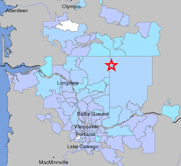
The Pacific Northwest Seismic Network got reports from people from Lake Oswego and Astoria Ore. up through Olympia.
The seismic network labeled it a light earthquake.
“A lot of those felt weak shaking,” Gibbons said.
This morning’s shaking was followed by at least eight aftershocks, two of which people noticed – one of 2.8 magnitude and another of 2.3, Gibbons said about 4 p.m. today.
“We haven’t had an earthquake like this with aftershocks in awhile,” Gibbons said. “We don’t usually get aftershocks that are felt.”
The last time the particular region saw an earthquake of similar size was a 3.9 earthquake on May 24, 2003, according to Gibbons.
Sgt. Ross McDowell, of Lewis County Emergency Management, said late this morning there were no reports of damage. However, because of its shallowness, folks could have cracking in their houses, he said.
Late this afternoon, the Lewis County 911 center had no calls reporting anything more than the quake was felt.
Scientists from the U.S. Geological Survey Cascades Volcano Observatory in Vancouver, Wash. reported this evening “(A)t present there appears to be no signs of unrest in the volcanic system.”
Gibbons said because the earthquake was only about three miles deep, “we think it’s just crustal faulting.”
By contrast, the quake on Nov. 16 near Mossyrock was about nine miles below the surface and initially recorded at 3.5 and upgraded to 4.2. It made the list of notable Pacific Northwest earthquakes since 1993, compiled by the Pacific Northwest Seismic Network.
Today’s quake was in the same area where two weeks ago more than a dozen small earthquakes were felt, according to McDowell.
McDowell said folks should remember we live in an earthquake zone and they should be prepared, because there is little or no notification for earthquakes.
Washington state typically experiences over 1,000 earthquakes each month, according to Lewis County Emergency Management. Of these, approximately two dozen a year are large enough to be felt.
The public can follow the earthquake data at the Pacific Northwest Seismic Network’s website
Follow observations of scientists at the U.S. Geological Survey Cascades Volcano Observatory in Vancouver, Wash. here

"Did you feel it?" response area map from the Pacific Northwest Seismic Network. / Courtesy image from Pacific Northwest Seismic Network
Tags: By Sharyn L. Decker, news reporter